Sixteen months after the Eaton Fire, a hiker dies on the popular Mount Wilson Trail
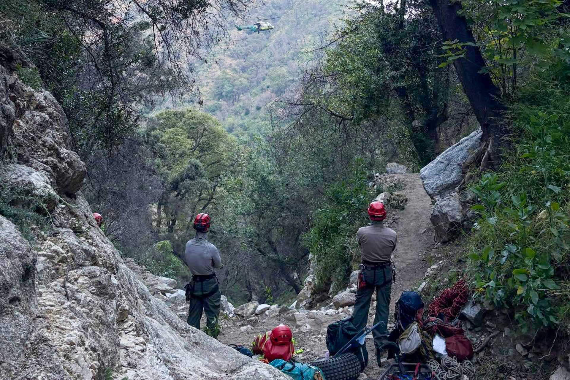
Just before 2 p.m. on Saturday, May 2, a 66-year-old man named John McIntyre slipped on a steep, loose section of the Mount Wilson Trail above Sierra Madre and fell about 30 feet into the ravine below the trail’s fixed-rope section. By the time Sierra Madre Search and Rescue reached him, he had succumbed to his injuries.
The trail Mr. McIntyre was hiking only recently came back online. After the Eaton Fire damaged 24 separate sections of it, volunteers spent the better part of a year rebuilding walls, bridges, and rock baskets to get the lower three and a half miles ready for use again. Above and around it, a much larger closure remains in force. On January 7, 2026, the U.S. Forest Service extended the Eaton Fire Area Closure through December 31, 2027, shutting down a long list of front-range trails and roads that aren’t going to be legal to walk on for another year and a half. Idlehour, Castle Canyon, all three sections of Sam Merrill, Echo Mountain, Mount Lowe Trail (East and West Trail), the Mount Wilson Toll Road, and Henninger Flats are all in the closure. Eaton Canyon itself, managed by L.A. County, is closed on a separate timeline that runs at least as long.
If you’re planning to head into the front range this spring or summer, it’s worth understanding what the trails that are open are actually like right now, what the volunteers keeping them open are dealing with, and what you should know before you go.
What a reopened trail looks like sixteen months after a fire
Rob Klusman, senior operations leader of Sierra Madre Search and Rescue, told Outside after the May 2 fall that the Mount Wilson Trail “has the same natural risks and hazards that exist on any trail, to some degree, in our mountains. You have steep, exposed, loose ground, lots of places where a slip and fall will have high consequences.” In his 30-year career with SMSR, Klusman has only seen a handful of fatal falls. The trail, he said, is safe.
Most fatal falls on this trail will be exactly what the official statements say they are: experienced hikers on technical sections of well-known terrain, where any slip has consequences. That’s true with or without a fire.
That said, a burn zone changes the texture of a trail in ways that aren’t always visible. Slopes lose the root systems that held them together, tread that looked solid a year ago may be undermined by a single hard rain, and substrate that used to be packed soil is now loose mineral earth. As Dana Dierkes, public affairs officer for the Angeles National Forest, told LAist: “One of the reasons why the soil isn’t always stable is because depending upon the severity of the burn, the whole entire root system may have been burned out.”
So the trail that comes back open after a fire may be a trail with the same line on the map but a different surface underneath. Lower Mount Wilson is in good enough shape to walk because volunteers spent a year putting it ther, but Upper Mount Wilson and the rest of the Eaton closure are not legal to enter, and that is for good reasons even Forest Service staff describe in plain terms.
The four hazards burn-zone trails carry that day-hikers underestimate
Loose, undermined tread. The hazard that killed John McIntyre is the same hazard the Forest Service describes in every closure order. After a severe burn, the surface of a trail and the slope below it have lost much of their structural integrity. Footing that holds for ten people in a row may give way for the eleventh. On exposed sections, that’s the difference between a stumble and a fall.
Debris flow risk during and after rain. A burned canyon doesn’t behave like a normal canyon when water hits it. State geologists told LAist that in the Eaton burn area, as little as one-fifth of an inch of rain in fifteen minutes is enough to trigger a debris flow. That’s a forecast threshold, not a hypothetical. If rain is in the forecast, the answer is to not be in any canyon downstream of an Eaton burn slope. This includes drainages that look fine on a sunny day.
Poodle-dog bush. Eriodictyon parryi is a native fire-follower that explodes across burn scars between 3,300 and 7,500 feet of elevation. Its tiny hairs cause a contact dermatitis worse than poison oak — swelling, rash, and an itch that lasts weeks. As the L.A. Times reported, it can dominate entire hillsides and persist for around a decade after a fire. It’s tall (up to 10 feet), has lavender bell-shaped flowers, and smells faintly like marijuana. Botanist Naomi Fraga told LAist it’s already established in the Eaton burn area and will be a feature of front-range trails for years to come.The standard poison-oak protocol of washing exposed skin with cold water doesn’t work — poodle-dog isn’t oil-based, and the irritant doesn’t respond to antihistamines. Long pants, long sleeves, and don’t touch anything you can’t identify.
Hidden hot spots and unstable rock. Forest Service staff continue to flag the possibility of root systems still smoldering underground months after a fire is officially out, and of loose rock and slow-motion landslides that don’t need a storm to come down. The trails that are open are open because the Forest Service and volunteer crews believe these specific issues have been managed on these specific corridors. The Altadena Mountain Rescue Team responded to a hiker shortly after the fire who entered the burn scar illegally and got disoriented by trail damage and the lack of vegetation. He couldn’t tell where the trail used to be.
The recovery you don’t see, and the people doing it
The reason any front-range trail is reopening at all is unpaid labor as the Forest Service does not staff a trail crew for this network. The work is done by volunteer organizations under formal partnership agreements with the agency, and by a small handful of individuals who have been doing it for decades.
In Sierra Madre, the lead volunteer for the first 3.5 miles of the Mount Wilson Trail is Bob Spears, a 74-year-old retired English teacher and former Sierra Madre Fire Department EMT. LAist profiled him in 2023 when he and a few volunteers were rebuilding the trail after winter storms and the lingering effects of the 2020 Bobcat Fire. The Eaton Fire forced him to start over. According to organizers of the Mount Wilson Trail Race, the Eaton burn destroyed 24 separate sections of the trail, requiring walls, bridges, fences, and rock-filled wire baskets to put it back. After last fall’s 5K Recovery Run drew 600+ runners through downtown Sierra Madre — triple what organizers expected — Spears said he was hopeful the funds raised would let his team finish the job. “Our goal is to have the trail ready when the USFS opens up the forest,” Spears told the Race Committee. “But remember that Chantry was closed for three years after the Bobcat fire. Our fingers are crossed.”
Higher up, in Eaton Canyon proper, the work is being done by the Lowelifes Respectable Citizens’ Club. Lowelifes was founded in 2019 by Matt Baffert, who works as a construction contractor and has been a trail steward in the Angeles National Forest for years under a formal agreement with the Forest Service. Baffert lost his Altadena home in the Eaton Fire. He also lost the organization’s trail-building tools when they burned along with his garage. Two months and six days after the fire, on the same day the Army Corps of Engineers cleared the rubble of his house, Baffert and fellow volunteer Eric Melanson rode into the upper Eaton Canyon to assess the damage to Idlehour Trail. They found large sections completely scoured by post-fire debris flows. A retaining wall they had built the previous spring was clinging to the edge of nothing, partially suspended in space.
Baffert estimated to LAist that it will probably be at least three years before Idlehour and other heavily damaged trails reopen to the public. That is consistent with what Spears observed about Chantry Flats after the Bobcat Fire: three years from fire to reopening, even with continuous volunteer work. As Baffert told LAist: “Altadena’s forever changed. But everybody just kind of wants what they had before. So working towards that, like rebuilding my home and rebuilding Idlehour, I think of them collectively. It’s a mission and I must do it.”
Both groups always need volunteers. Lowelifes runs trail-work weekends and overnight campouts year-round and accepts hikers, runners, and mountain bikers. Sign up at lowelifesrcc.org. The Mount Wilson Trail Race Committee channels donations directly to Spears’ work; their site is mountwilsontrailrace.com.
What to actually do this season
Three things, in order of importance.
Respect the closure. The Eaton Fire Area Closure has the full list of closed roads and trails and runs through December 31, 2027. Going around the gates isn’t bravery, it’s putting search and rescue volunteers in danger when something goes wrong, and it’s also a federal violation under 36 C.F.R. § 261.50. Don’t.
The lower Mount Wilson Trail is open, as is much of the rest of the front range outside the closure. Pack like you’re on exposed terrain with degraded tread, because you are. Trekking poles. Real shoes. Long sleeves and long pants if you’re heading into burn-zone vegetation. Water for you and your dog (Spears installed a heat-warning sign at the trailhead specifically because of the rate at which dogs were collapsing on this trail). And — Klusman’s point, which is the one most worth internalizing — be prepared to survive on your own for an extended period if something goes wrong. SMSR doesn’t appear instantly. Even from a Los Angeles trailhead, a rescue can take more than an hour to reach you, and in some cases you may be spending a night out before help arrives.
You might also consider volunteering. The trails that reopen the soonest are the ones with the most hands working on them. Lowelifes and the Mount Wilson Trail Race Committee are both running active programs and would welcome anyone reading this. The front range that comes back is going to be the front range these volunteers build.
Sources: U.S. Forest Service Eaton Fire Area Closure order; Sierra Madre Search and Rescue (via Outside, KTLA, Patch, Pasadena Now); LAist coverage of Bob Spears, Matt Baffert and the Lowelifes, debris-flow risk in the Eaton burn scar, the post-fire forest reopening, and poodle-dog bush; Lotus Rising L.A. and Pasadena Now on the 2025 Mount Wilson Trail Recovery Run; Lowelifes RCC’s own field reports from the Idlehour assessment; Mount Wilson Bicycling Association poodle-dog bush identification guide; Singletracks on the front-range trail damage.