Keysville Recreation Area Camping and Adventure Guide

Nestled in the heart of California, the Keysville Recreation Area is a historic mining locale that seamlessly blends natural beauty with rich cultural heritage. Situated amidst rolling terrain covered with blue oak and foothill pine woodlands near the town of Lake Isabella, Keysville is traversed by the lower Kern River, offering diverse landscapes and a multitude of recreational activities, including hiking, camping and off-roading.
Visitors can explore historic mining structures, engage in white-water rafting, fishing, gold panning, and enjoy over seventy miles of trails suitable for mountain biking, equestrian, and motorized adventures. This area is a must-visit for outdoor enthusiasts and history buffs alike, providing a unique blend of adventure and exploration.
Destination Details
| Season | Year-round (summer activities best in cooler parts of the day) |
| Location | Keysville Recreation Management Area, California |
| General GPS Coordinates | 35.63329167, -118.4950611 |
| Management | Bureau of Land Management |
| Size | Approximately [Specify Size if Known] square miles |
| State | California |
| Nearest Major City | Bakersfield, CA (about 80 miles away) |
| Information Number | 661-391-6000 |
How to Get to Keysville Recreation Area

From the junction of CA-178 and CA-155 at the town of Lake Isabella, take exit 155 onto CA-155. Keysville South entrance (for camping and river access) is approximately 0.6 miles from this junction on the left (west) side of the road before crossing the Kern River. Keysville North entrance (for camping, OHV, and other trail use) is on the left another 0.4 miles down highway 155, just past the bridge across the Kern River.
Destination Overview


The Keysville Recreation Area is a treasure trove of both natural and historical attractions. The area is characterized by its rolling terrain, dotted with blue oak and foothill pine trees, and bisected by the lower Kern River. This diverse landscape supports a wide range of recreational activities, from exhilarating white-water rafting and fishing to the leisurely pursuits of gold panning and dispersed camping.
Keysville is steeped in history, with remnants of the Kern River Gold Rush visible throughout the area. Visitors can explore various mining structures, including the notable Walker Cabin and a historic fort, providing a glimpse into the region’s past.

The extensive network of over seventy miles of trails caters to mountain bikers, equestrians, and motorized vehicle enthusiasts, ensuring that there is something for everyone. Keysville includes three recreational management areas that are particularly popular for camping and off-roading: French Gulch, Gold Fever, The Dam, and Wallow Rock. The French Gulch area, in particular, offers a number of off-road trails.
Safety is paramount in Keysville, especially near the river. Swimming is discouraged, and visitors are advised to exercise extreme caution around the river’s edge. Always wear a life jacket when engaging in boating activities to ensure a safe and enjoyable experience.
Whether you’re seeking adventure on the river, eager to delve into history, or looking to explore the extensive trail systems, Keysville Recreation Area offers a diverse and enriching outdoor experience for all who visit.
Here’s a map showing more detail on the different areas and trails:

Camping at Keysville Recreation Area
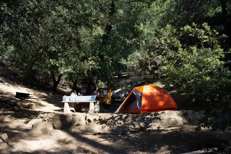
Keysville Recreation Area offers a variety of camping experiences tailored to outdoor enthusiasts seeking both solitude and adventure amidst California’s scenic landscapes. The area primarily supports dispersed camping, allowing visitors to camp in undeveloped areas away from designated sites.
This type of camping provides a more rustic and immersive experience, ideal for those looking to fully engage with the natural surroundings. BLM is currently considering reducing the dispersed camping options in the area, so it’s a good idea to check in with the field office (number above) to find out the status of camping areas.